by Rainer Hoenicke
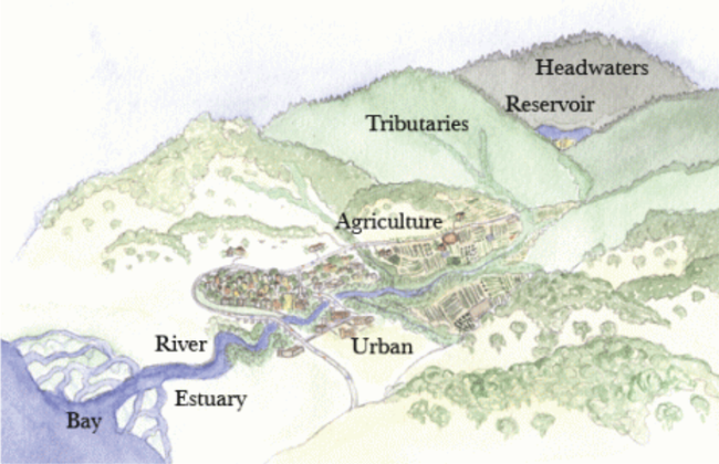
What do those of us who live in a Napa townhouse with a 500 square-foot patio area as their backyard and those living out in the countryside on a 5-acre ranchette have in common? We all live in a watershed – the area of land that drains all the rainfall to a common outlet, such as a confluence point along a stream or river channel, a tidal marsh, or coastal lagoon. Watersheds can be as small as a footprint or as large as the whole land area that drains into San Francisco Bay and ultimately the Pacific Ocean (roughly 40% of California's land area). The geology, vegetation cover, and land use determine what portion of rain gets absorbed into the soil, evaporates from leaves before it can reach the ground, runs off into the nearest storm drain or creek channel, or gets stored below-ground in the aquifer. A watershed is essentially a precipitation collector. And gardeners, in particular, are strongly aware of the importance of water, since nothing can grow without it, and therefore life could not exist.
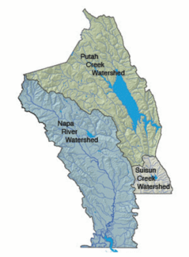
Why does it matter that we know what watershed we live in, and what processes have been and still are shaping the soil we are growing things in? The answer is simple and complex at the same time. Everything that happens upstream of where we live will in some way affect our own plot of land, no matter how large or small. If a landfill's liner leaks, and you live downstream of it, the cadmium and nickel in batteries that were inappropriately thrown into the household garbage might end up in the lettuce you are growing or the water pumped from your well. Or some of the road cuts made in the hillslopes over the last century are to this day contributing sediment from slope failures to the valley below, and homeowners living next to a stream on the valley floor may see that soil in their basement or on their front porch after a major flood. And the oil drippings from parked cars will find their way into storm drains and eventually the Napa River, where that oil may affect the aquatic insects living there that are food for migrating or resident fish. It matters how human modifications have altered where and how rainfall runs off, where it ends up and how much of it can or cannot be absorbed into the soil, accommodated by a stream or river channel and what the rain does to soil, stream banks and vegetation.
Napa Valley Historical Ecology Atlas, a wonderfully illustrated history of the Napa Valley landscape, comparing notes and records of the early settlers and how it has evolved with humans altering the Valley over time and the watersheds draining into the Napa River, was written by Robin Grossinger and published by UC Press in 2012. I use it frequently to find out why my mature fruit trees survive the five-month-long dry season with minimal irrigation, and under what circumstances they do need a bit of watering support. It explains why some vineyards can be dry-farmed and, more often than not, produce wines of exceptional quality, why my backyard has in some places standing water in it for days or even weeks between December and April and why certain native plants initially didn't thrive until I added some mounds and re-planted them above the surrounding soil surface. I found out that our whole neighborhood used to be a wet meadow where the early settlers had difficulty planting orchards and mostly used the land for grazing. Groundwater is at or near the surface during the wet season and four to eight feet below the surface during the dry season. Apparently, Salvador Creek, with its headwaters in what is now Alston Park, dropped the fine sediment load that it carried from the hillslopes into what is now my neighborhood and created a dense clay layer in places. In my yard, this layer is anywhere between one and two feet below the surface. Just north of us, Dry Creek, with much larger flows than Salvador, deposited coarser sediment on the valley floor, such as sand and gravel, creating what are known as “alluvial fans,” which to this day in most of the Napa Valley serve as great groundwater recharge areas. In the lower part of the Valley, south of Oak Knoll Road, ground water is generally close to the surface – not just in my neighborhood. Some of the old-timers, like me, may remember the time when the Highway 29 underpass at the juncture of Trancas and Redwood Streets was built, and Caltrans had to install pumps to divert groundwater to Napa Creek even during the dry season to avoid groundwater emergence from flooding the underpass.
The more we know about the larger landscape - from the hilltops to the valley floor – the more we can infer about what kinds of plants will thrive in our miniature backyard ecosystems, what kinds of animals even our urban landscapes can support, and how to be good stewards. Napa County is one of the most biodiverse regions in the whole state, to which climate, a huge range of rainfall gradients, and soil types contribute. And as climate change brings more extreme weather events, we can help mitigate the effects through our individual contributions as gardeners to soil health, carbon sequestration and water conservation, all of which will scale up all the way to the watershed as a whole.
Master Gardeners are following recommended social distancing guidelines that keep everyone safe, Napa Master Gardeners are available to answer garden questions by email: mastergardeners@countyofnapa.org. or phone at 707-253-4143. Volunteers will get back to you after they research answers to your questions.
Visit our website: napamg.ucanr.edu to find answers to all of your horticultural questions.
Photo credits:
Napa Watershed Information and Conservation Council. https://www.napawatersheds.org/
Informational links:
https://www.napawatersheds.org/
Ca Water Conservation: https://www.google.com/url?sa=t&source=web&rct=j&url=https://www.conservation.ca.gov/dlrp/Educational%2520Documents/California%2520Watersheds.pdf&ved=2ahUKEwi6sceU2KTqAhUFrJ4KHXd9CtgQFjABegQIBRAC&usg=AOvVaw37TaEqEStKPpKh7vYEoF6v

